
Directions to DeepSky Ranch
Please print out these directions and bring them with you. There is no cel phone coverage in a 25-30 mile radius around the ranch, so I can't talk you in.
GPS Coordinates
- From San Francisco Bay Area Via U.S. 101
- From San Joaquin Valley or Los Angeles Via U. S. 5
- Map from Panoche Road to DeepSky
- Picture of Deepsky Ranch from Antelope Creek Rd. in Willow Springs
- Google Map
GPS Coordinates
The ranch can be found at 36 degrees 39.25N & 121 01.34W
Directions from US 101
Summary:
This route covers about 41 miles. Please note that cel phone coverage between Tres Piños and Panoche Junction is spotty at best. There is no cel phone coverage from the time you turn onto Panoche Road/J1, none, nada, zip. There are a few scattered ranches along the route, and if someone's home, they might make a call for you in an emergency. Plan accordingly.
- From Highway 101 take Highway 156 to Union Road (~7 miles).
- Turn right on Union, go to Airline Highway (Highway 25) (~5miles).
- Turn right on 25; go to County road J1 in Paicines (~9 miles).
- Turn left onto J1. Go ~ 20 miles to the “Willow Springs" subdivision on left.
- Turn left onto Antelope Creek Road and go about one mile, then take the first “street” on left (no house numbers).
- The house is the first driveway on the left, a brown adobe house.
Detailed Directions:
- Exit 101 at the San Juan Bautista exit, Highway 156 to the EAST (right from the freeway). Start your trip meter (0 miles).
- Go through the first light – continue on Hwy. 156 (about 3.4 miles).
- Turn right at the 2nd light, Union Road (about 7.1 miles).
- Follow Union Road to Highway 25, Airline Highway (about12 miles).
- Turn right onto Highway 25.
- Go through the town of Tres Piños – this is the LAST GAS STATION.
- Continue on Highway 25 to Paicines; turn left onto County Road J1, also called Panoche Road (about 21 miles). There is a little store there and a historical marker for the New Idria mine.
- You’ll shortly pass the Blossom Hill Winery, AKA "the wine factory."
- Continue on County Road J1 for about 20 miles. You’ll go over two one-lane bridges.
- At about the 39 mile mark (from 101) you’ll come to a stream that goes over the bridge – do not cross if the water is running strongly over the road.
- At about 39.6 miles from 101, you will see a gate with the sign “Willow Springs” on the top, mailboxes and a sign marking Antelope Creek Road on the left side of the road (Panoche Road, J1).
- Turn left onto the dirt road. If you miss the road, you will immediately cross another place where a stream goes over the road when raining and there is a CDF fire station with green buildings on the right. If you go past the fire station on the right, you have gone too far east.
- Go about one mile up the dirt road, turn left on the first road that is not a driveway.
- 20295 Panoche Road is the brown adobe house at the first driveway on the left, up about 0.1 miles from the last turn.
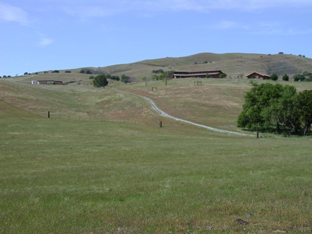
Deepsky Ranch as seen from Antelope Creek Rd. in Willow Springs.
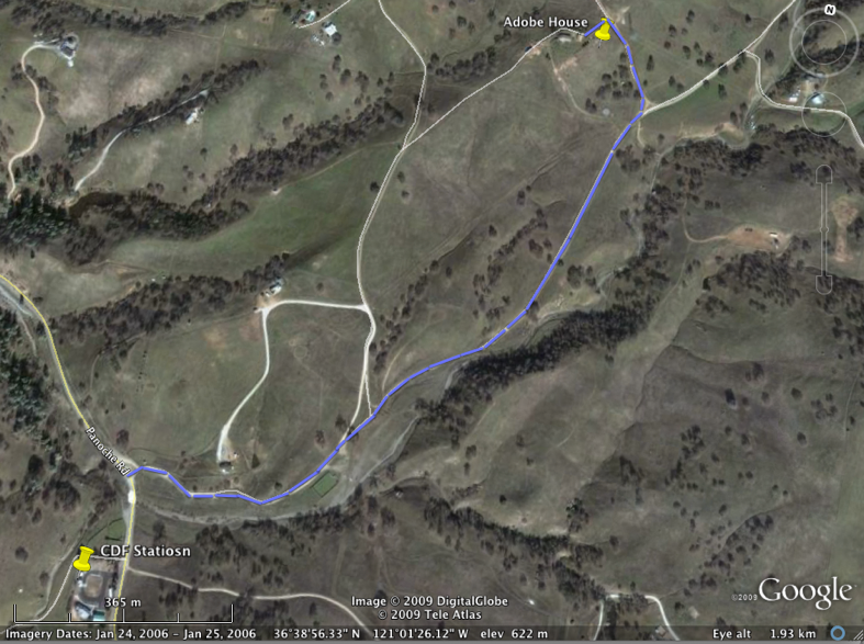
Route from Panoche Rd. through Willow Springs to DeepSky Ranch.Directions from Interstate 5
Summary:
This route covers approximately 32 miles. Please note that there is no cel phone coverage from the time you take the exit from Hwy 5, none, nada, zip. There aren't even power or phone lines until you get to Panoche Junction. Neither are there any habitations, apart from Mercey Springs Resort, about 13 miles in to the trip, and the Panoche Inn about ½-mile after the right turn onto Panoche Rd. There is a landline phone at Panoche Inn (Say "Hi" to Larry or Cindy if you stop there. They have wonderful sandwiches with homemade bread-and-butter pickles). Plan accordingly.
- From Interstate 5 exit at the Highway J1/Shields Road exit. Take J1 (go West) to Panoche on Little Panoche Road (~ 21 miles).
- Turn right on Panoche Road (still highway J1).
- Follow Panoche Road/J1 through the hamlet of Panoche for about 10 miles to the CDF Fire station, which are the green buildings on the left.
- Just past the fire station, turn right onto Antelope Creek Road and go about one mile, then take the first “street” on left (no house numbers).
- Our house is the first driveway on the left, a brown adobe house.
- Caution: there are NO GAS STATIONS after leaving Interstate 5.
Detailed Directions:
- Get out of LA, get to Interstate 5 — Go North on Interstate 5 for several hours, till you are seeing signs for Highway 152 that would take you into Silicon Valley. If you get to Highway 152, you have gone too far.
- Do NOT take the first Panoche Road Exit you see on Interstate 5 (near a little town called Apricot Tree) – it is a dirt road over a mountain pass.
- About 10 miles further up Interstate 5 you will come to Shields Road – it goes to Mendota if you go right (east). Take the road to the West, it will be called Little Panoche Road or County Road J1.
- Continue on County Road J1 for about 21 miles—this road gets very curvy.
- About 30 miles after you leave Hwy. 5, you will see a CDF Fire Station on the left. Just past it there is a stream that goes over the road – do not cross if the water is running strongly over the road.
- Just past the stream crossing you will see a gate on the right with the sign “Willow Springs” on the top, mailboxes and a sign marking Antelope Creek Road on the right side of the road (Panoche Road, J1).
- Turn right onto the dirt road. If you miss the road, you will come to a second stream crossing in about a mile, you have gone too far west.
- Go about one mile up the dirt road, turn left on the first road that is not a driveway. 20295 Panoche Road is the brown adobe house at the first driveway on the left, up about 0.1 miles from the last turn.
Google Map
This map will give you a general idea of location, but it isn't reliable as to details. As mentioned before, print out the directions and bring them with you.
View Larger Map